
IV De Kinkhoorn
De Kinkhoorn 20 — October 2009
Volume 10, number 2
This issue as pdf (Dutch) · Read the Dutch original
Foreword
On 8 July last it had been ten years since the Stichting Kingma State was founded. The foundation was established to organise the Kingmadag on 8 July 2000 and to carry out further research into the genealogy and history of the Kingmas and a possible rebuilding/new construction of the State.
Thanks to our donors we have been able to publish the "Kinkhoorn" twice a year and organise a donors' day in Zweins every year. In 2005 we also organised a day for the Kingmas living abroad, in Zweins.
Meanwhile a great deal of data has been collected on the genealogy and history of the Kingmas and the State up to 1700. As indicated in the previous "Kinkhoorn", we will look into whether what is now available offers sufficient material for a future publication, and carry out further research into historical documents. The board will also consider the further continuation of the foundation and in what form. During the Kingmadag on 7 November in Zweins, we will inform you further about this, as well as about our intention regarding a publication on Kingma State and its inhabitants up to 1700.
In this "Kinkhoorn" you will find the fourth article on old maps of Zweins and its surroundings; we have also included an article on the Sjaarda family and their relation to the state Kinghum. We also have a sequel to the articles on Ignatius Kingma and the Battle of Lobith concerning the controversy with Louis XIV.
I hope to meet many of you on 7 November in Zweins.
Tjeerd Kingma
Chairman
Zweins and Kingma State on old maps (4)
Since the publication of the first provincial map of Friesland, made by Jacob van Deventer in 1545, a long series of maps of Friesland that can be called historic has appeared. In making a new map, extensive use was generally made of earlier maps. Maps based on actual surveys, which served as a model for later maps, are referred to as base maps. A base map together with its followers is called a group by P.J. de Rijke in his book Frisia Dominium, and is designated with a capital letter. In doing so he distinguishes five groups for the period from 1545 to 1823. The base maps here are the maps of: A. Jacob van Deventer, B. Sibrandus Leo, C. Pier Winsemius, D. Bernardus Schotanus à Sterringa, E. Abraham Allard and F. Krayenhoff.
Group A, with as its base map the map by Jacob van Deventer of 1545 (see Kinkhoorn 17), produced a series of followers, e.g.: Christiaan Sgrooten 1573 (see Kinkhoorn 19); Michele Tramezini 1556; Giovanni Francesco Camotio 1556, which in turn was based on Tramezini; Abraham Ortelius 1568; Gerard de Jode 1568 and Frans Hogenberg 1571.
The so-called Pauwenkaart (Peacock Map) by Sibrandus Leo of 1579 (see Kinkhoorn 19) is the base map of group B. This map, too, has followers, such as: Frans Hogenberg 1579. Here too, just as on the map by Sibrandus Leo, two small circles are drawn near Zweins along the trekvaart.
The map by Lodovico Guicciardini
While maps in group B were already being made, the followers in group A continued as well, such as Lodovico Guicciardini, a Florentine nobleman who worked in Antwerp.
See the map below, from 1581, with detail.
This map appears in the Italian edition Descritione di tutti Paesi Bassi by Christoffel Plantijn, a publication of maps and descriptions of the Netherlands. The map has much in common with the map by Ortelius from 1568.


Zweins, written as Sweijns, is, like all villages, indicated with a small circle filled in red.
A later map by Guicciardini from 1609 is based on the map by Sibrandus Leo, and thus belongs to group B.
A map from the atlas of Gerard Mercator, 1585
Gerard(us) Mercator, born as Gerard Kremer in Flanders, became known, among other things, for the Mercator projection, which he introduced in 1569. This projection is created by projecting the globe onto a cylinder and then unrolling it into a flat plane. As a result, all meridians become straight lines. This had the advantage, especially for shipping, that a straight compass course is also a straight line on the map. One of the drawbacks is the well-known distortion of area, whereby regions are shown larger the further they lie from the equator.
In 1585 the first 51 maps of Mercator's World Atlas appeared, including the map of Friesland shown below.

In making these maps he made use of the work of Christiaan Sgrooten for his Brussels atlas of 1573. The maps therefore fall under group A.

The towns are indicated with a gate or castle, the villages with a small circle. Zweins is written as Sweyns and positioned on the trekvaart.
Between Sweyns and Ryp two side canals are drawn along the trekvaart. Taking into account the imprecise indication of the location of the villages, the southern one could be the Hatsumer opvaart. The northern one could then be the opvaart running past Kingma State, which according to Bauke Saakstra would have continued as far as Ried?
A variant curious to us within group A is the map below by Johann Bussemacher from 1592.

On this map it is not north but west that is at the top.
Zweins is not indicated on this map.
King Louis XIV and Ignatius van Kingma in the battle of Lobith in 1672
In various issues of the Kinkhoorn we have reported on the military exploits of Colonel Ignatius van Kingma (1621–1700). Among other things, on his involvement in the Battle of Lobith on 12 June in the disaster year 1672, in which the French 'Sun King' Louis XIV invaded the Republic of the United Netherlands across the Rhine.
This spring, during a conversation with mayor Mark Slinkman of the municipality of Rijnwaarden, I learned that he has an image of a large painting of this battle in the town hall in Lobith. Further research led me to the original in the Rijksmuseum: a canvas of just over one by one-and-a-half metres by the painter Adam Frans van der Meulen.
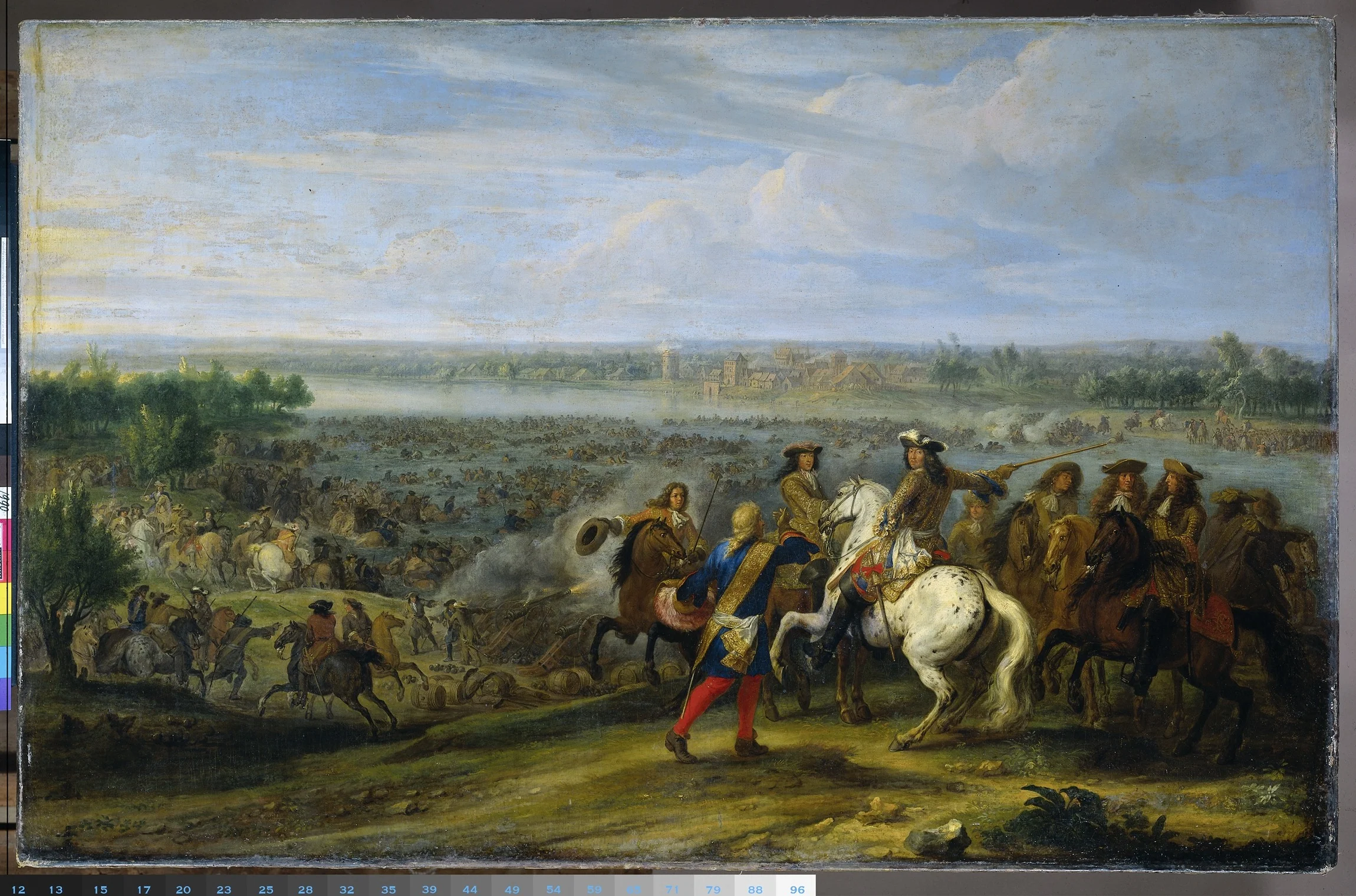

Van der Meulen was present at the French invasion. As a war painter he had been in the service of Louis XIV since 1664. He specialised in painting battles. Van der Meulen made these paintings on the basis of preparatory sketches. These had to be made on the spot. That is why the painter travelled with the French armies.
What do we see in this painting?
The Rhine near Lobith in Gelderland on Sunday morning, 12 June 1672. Under cover of cannon fire, French soldiers descend the riverbank. Some of them wade across the river. On the far side they are met by Dutch cavalry. Some of these mounted soldiers have also entered the river. The round tower of the Lobith tollhouse has been hit by French fire. Seated on a dappled grey horse is a man dressed in a red and blue brocade costume. Around his waist he wears a white sash. It is the King of France in person: Louis XIV. With his right hand he directs his troops across the river. He is surrounded by a group of officers. In the foreground stands a man dressed in red and blue, hat in hand. This is probably the local farmer or ferryman who told Louis where the river was fordable.
Colonel Ignatius van Kingma, with his regiment, is part of the Dutch cavalry on the far bank. In the hours that follow this scene, the cavalry has to retreat under the French superior numbers, and the Battle of Lobith is lost.
In the book 'Rampjaar 1672. Hoe de Republiek aan de ondergang ontsnapte.' by Luc Panhuysen, published this year by publisher Atlas, a vivid description is also given of this battle. After General Montbas had withdrawn his infantry and cavalry (including Ignatius's regiment) from the defensive line on his own authority, Stadtholder William III had him arrested and sent Field Marshal Paulus Wirtz with a number of Frisian regiments back to the Rhine to close the breach in the line.
"Wirtz arrived on 12 June with his small army on the bank of the Rhine at Tolhuis (= Lobith, JK). The French army already stood in battle order on the other side. Wirtz positioned three cavalry companies opposite the fordable spot and stationed a regiment of Frisian infantry plus a number of cannons at the tollhouse, several hundred metres further on. The French cavalry was not afraid. Two thousand plumed horsemen raised their swords to the sky in salute to their king, who watched the scene from the Elterberg, and plunged into the river with much splashing. It was a reckless attack. The mass of horsemen formed an easy target for the Dutch cannons and musketeers. But the French cannons soon silenced the Dutch fire. The Dutch cavalry then took to their heels and left the Frisian infantry to the mercy of the French horsemen."
The infantry also wanted to break off the fight, but the French charged at them with drawn swords. A fight followed between the infantry and the French cavalry, in which many French and Frisians lost their lives.
From this passage and the painting it is clear that the cavalry, including Ignatius van Kingma with his regiment, took part in the fighting. The description also gives the impression that they broke off the fight rather quickly and abandoned their Frisian comrades of the infantry. In the book Het Staatsche Leger by Ten Raa and De Bas from 1921, this picture is confirmed: "Wirtz reached the Tolhuis, while the enemy cavalry was in the process, partly swimming, of crossing the river ... Wirtz went with his foremost companies of horsemen to meet the enemy in the water, but was not supported by the following units; his horsemen took to flight."
The question of whether Ignatius was in the front or rear ranks of the cavalry, and how bravely he conducted himself, cannot be answered on the basis of this information. What explains the rapid retreat of the cavalry is the enormous superiority in numbers of the French king's army of 120,000 men — the largest that Europe had seen since the Roman Empire — against a few thousand men on the Dutch side. The fact that his artillery had also quickly put the Dutch guns out of action means that the cavalry must have concluded fairly soon after the hastily launched counter-attack began that the defence of this point was a hopeless undertaking.
Joost Kingma
The Sjaardas’ relationship with the state Kinghum
In the vicinity of Franeker there are many kwelderwallen (raised salt-marsh ridges). On one of these kwelderwallen lay four terpen that still bear their names today: Edum, Sjaarda, Salverd and Kinghum. We may therefore assume that farmers were already living on the terpen more than 2000 years ago. The habitation of these terpen is thus very old. But the terpen have told us nothing, because when they were dug away at the end of the 19th century this was not done in a scientific manner.
Franerker-Uitburen, formerly counted as part of the first division of the grietenij of Franekeradeel, province of Friesland, quarter of Westergo, now consisting of the neighbourhoods of Arkens, Salwerd, Lutje-Lollum, Miedum, Doyum, Kie, Lankum and War. Westergo was one of the 3 gouwen (regional districts) in Fryslân, which were formed in the period 800–900 AD. At the head of the gouwen stood counts. From around 1250 the counts had disappeared and the gouwen stood practically on their own. Families such as the Sjaardas controlled the gouwen. Over time these neighbourhoods came under the town of Franeker, probably shortly after 1500, presumably in order to share in the privileges and prerogatives which the Duke of Saxony had granted to that town and its citizens because they had shown him their loyalty.
The Staten (farms) situated in those neighbourhoods were also entitled to the office of grietman, as is apparent from the old Staten at Salverd, at Lutje-Lollum, Lankum and Gedserda, all of which staten, between 1406 and 1438, exercised in their turn the right within the grietenij. Around 1400 the farms on this kwelderwal were in the possession of the Sjaardas. In the "Ordinatie van de rechtsomgang in Franekeradeel" and also in the accompanying register, running from 1406 to 1438, we encounter the state Kinghum as the rechtvoerende state of Sweins. A rechtvoerende state had the right to appoint one of the eight judges of Franekeradeel once every so many years. One of those eight was appointed grietman (mayor). Thus Sicke Sjaarda was judge of Sjaarda in 1409; judge of Salverd in 1408 and judge of Kinghum in 1413. The order was such that Kinghum could appoint a judge once every seven years. One may well conclude that in 1413 Kinghum had Sicke Sjaarda as its owner, who could also regard Salverd, Sjaarda and Edum as his property". One may certainly assume that the Sjaarda family was a powerful family in Westergo from the 13th through the 15th century. There is a hypothesis that the Sjaardas may have been heirs of the so-called king's men of the Frankish king Louis the Pious. So even before the 13th century they, or their ancestors, had quite a stake in things. Thus a certain "Sicka (Sikko – Sikke) Syarda" appears to have been chosen 'Potestaat' {an administrator appointed by the emperor, but not a territorial lord} in 1237. Count William II of Holland offered Sicko the (hereditary) lordship over the Frieslands. He is said to have refused this offer with the words:
Grootmagtige Koning ! Wil u niet te vergeefs vermoeijen; meent gij dat ik, om mij en mijn geslacht te verheffen, een verrader wil zijn, en de nakomelingen van die vrijheid berooven, welke onze Voorouders boven alle goederen geschat hebben? Verre zij van mij een geldgierig en oneerlijk hart! Vaarwel! En wil mij met uwe brieven niet meer begroeten in dier voege, want ik wil na dezen geene van u ontvangen”. Uit onzen huize Sjaardema den 9 Augustus 1239".
Petrus Thaborita writes of him as 'Sickes Syarda', who during his "regnacie" (reign) once had to fight a battle. In 1250 Abel, "Koninc van Noertweghen", attacks East Friesland. The Frisians kill the king and many of his men. Petrus was almost right; the correct year was 1252 and that king was Abel of Denmark. Sicka is said to have had a son, a certain "Sicke Sjaerdema", who was born around 1290 in Franeker and died on 17 September 1345 in Warns; married around 1320 in Franeker to 'Edwert Gerbranda'. Edwert is said to have been born around 1293. From the marriage of Sicke Sjaerdema and Edwert Gerbranda came, among others: "Douwe Sickes Sjaerdema", born around 1328 and died in Franeker in 1416; who married around 1345 Trijn Roorda, born in 1325 in Tjummarum and died in Franeker/Arum. In 1406 a certain 'Goffe Zyaerda' is mentioned, son of Goffe (presumably the same person as Sicke) Sjaerdema and Edwert Gerbranda. He in turn had a son, named "Sicco Sjaerda", married to Both Hobbema, died in 1422. "Edwer Sjaarda" (daughter of Sicke Sjaerdema) built the Sjaerdemaslot on what is now Sjûkelân between 1446 and 1449. The period from 1250 to 1500 is called the Frisian Freedom; during that time there were no foreign rulers in Fryslân. However, when in 1500 the government of Albrecht of Saxony took up residence in the castle of the Sjaardas, the Frisian Freedom came to an end and the rulers no longer spoke Frisian. Franeker then (once again) became the capital of Fryslân and was governed from what is now Sjûkelân.
Text downloaded from a webpage on the Hyves site of the Van der Schaaf family. Source of the text unknown.
Kingma Kronkels: Stinzen

Joost Kingma
This spring, Paul Noomen's book De stinzen in middeleeuws Friesland en hun bewoners appeared. That was our reason to invite him as a speaker at our donors' meeting in November. Naturally you want to read such a book right away, curious whether there are any new interesting facts to discover about Kingma State. And of course to enrich your understanding of the origin and habitation of states and stinzen.
Well, the latter certainly delivers, and Noomen's knowledge on this subject is bound to lead to a fascinating talk at the autumn meeting.
The former, learning more specifically about Kingma State, yields only a limited catch — one that, moreover, was largely already known.
An important source for our knowledge of Kingma State is the Rechtsomgang van Franekeradeel covering the years 1406 to 1438, which was published and annotated in a modern edition by Overdiep and Tjessinga in the 1950s.
This shows that there were about 250 sates in Franekeradeel, of which only 92 — the rechtvoerende staten (the states entitled to supply a judge) — carried the right to provide a co-judge to the grietenij court. Kingma at Zweins is one of them. At that time this state was still leasehold property of the powerful Sjaerdas, who thereby also held the right to supply a judge. Kingma, incidentally, only came up for its turn 3 times in 126 years under this system of rotation. In total, Noomen calculates that the Sjaerdas, with all the staten they owned, qualified at least 43 times.
It is also interesting that Kingma was nevertheless quite significant. In 1529 it belonged to the select group of nine staten with the right to keep swans, together with the Sjaerdas and Heremas, families with a position of power beyond the local level. Pieter Jelles thoe Kinghum claimed this right, contested by the heirs of Sjaerda.
But then, by that time they were already becoming freeholders themselves.
Colophon
'De Kinkhoorn' is a periodical publication of the Stichting Kingma State. The foundation aims to promote historical research into the former country estate, its inhabitants and their descendants.
If you are interested in the work of the Stichting Kingma State, you can become a donor. By doing so you support the historical research and you will periodically receive De Kinkhoorn.
In the autumn, usually in November, the foundation organises a donors' meeting with lectures.
You can become a donor by registering with the foundation by post, e-mail or via the website, and transferring your annual donation (target amount at least €22.50, minimum €15.-) to account number 55.00.97.538 at ABN AMRO bank in Arnhem, in the name of Penningmeester Stichting Kingma State.
Print run: 150 copies.
Published at least twice a year.
Stichting Kingma State
Secretariat: Sterrenboslaan 20, 3972 GD Driebergen
tel: 0343 521212
fax: 0343 517689
e-mail: info@joostkingma.nl
website: www.kingmastate.nl
Board: Chairman: Tj. Kingma, Zwolle
Secretary: J.H. Kingma, Driebergen
Treasurer: J.M. Kingma, Arnhem
Board member: C.S.J. Kingma, Emmen
Design and production: Drukkerij Bakker Baarn
This publication is registered with the Koninklijke Bibliotheek (Royal Library) under ISSN: 1569-8645
In case of full or partial reproduction of the content of articles from De Kinkhoorn, please cite the source.